


|
|||
|
|
| |||||||||||||||||||||||||||||||||||||||||||||||||||||||||||||||||||||||||||||||||||||||||||||||||
| Print Chapter 3 (PDF 2,563KB) | < - Report Home < - Chapter 2 : Chapter 4 - > |
Introduction
Background
Features of the Agreement
Consultation
Implementation and entry into force
Conclusion and recommendation
Introduction |
|
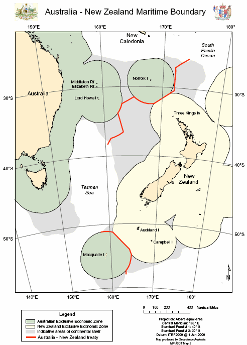
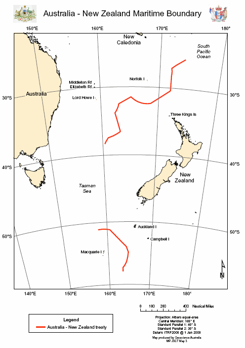
| 3.1 | The Treaty between the Government of Australia and the Government of New Zealand establishing certain Exclusive Economic Zone Boundaries and Continental Shelf Boundaries (Adelaide, 25 July 2004) (the Treaty) will define the Exclusive Economic Zone (EEZ) and continental shelf boundaries between Australia and New Zealand in the Tasman Sea and adjacent areas of the south-western Pacific Ocean. There are currently no agreed maritime boundaries between the two countries. |
Background |
|
| 3.2 | The NIA provides that under the 1982 United Nations Convention on the Law of the Sea (UNCLOS) coastal States are entitled to a continental shelf and EEZ of up to 200 nautical miles from the baselines from which the breadth of the territorial sea is measured.1
Where the natural prolongation of a coastal State’s landmass extends beyond 200 nautical miles, the State is entitled to an additional area of shelf within limits established under UNCLOS. The maximum extent of the continental shelf in these circumstances is determined by a complex set of rules, but in no one case can it exceed the greater of 350 nautical miles from the baseline or 100 nautical miles from the 2500-metre isobath (a line connecting all points lying at a depth of 2500 metres).2 Where the entitlements of States overlap, as they do with Australia and New Zealand , it becomes necessary to delimit maritime boundaries in order to provide certainty of jurisdiction and thus a secure basis for the resources of the maritime zones to be exploited.3 |
Features of the Agreement |
|
| 3.3 | The Department of Foreign Affairs and Trade informed the Committee that the EEZ boundaries between Australia and New Zealand are delimited in six places along the line of equidistance:
|
| 3.4 | However, not all of the boundary runs along the equidistance line. Where an isolated island of one country lies close to the much longer coastline of another country, it is consistent with international law and practice for the boundary to be located closer to the isolated island.5 The Department of Foreign Affairs and Trade went on to explain that:
|
| 3.5 | Concerning the maritime boundaries between Macquarie, Auckland and Campbell Islands being drawn back along Australia’s EEZ, the Committee heard evidence that:
|
| 3.6 | The Treaty does not delimit the maritime boundaries (territorial sea, EEZ and continental shelf) between the Australian Antarctic Territory and New Zealand’s Ross Dependency. New Zealand, which has not yet declared an EEZ in this area, was not willing to delimit these boundaries for the time being.8 |
| 3.7 | Comparisons between the New Zealand-Australia maritime boundary negotiation and the East Timor-Australia maritime boundary negotiation arose during the course of the public hearing. The Attorney-General’s Department outlined the general differences between the two negotiations:
|
| 3.8 | The Attorney-General’s Department later remarked that:
|
| 3.9 | Articles 2 and 3 of the Treaty establish the areas in which each country may exercise sovereign rights and jurisdiction. In the EEZ, the coastal state exercises sovereign rights to explore and exploit, conserve and manage the living and non-living natural resources. It also has jurisdiction to protect and preserve the marine environment and to undertake marine scientific research. On the continental shelf extending beyond 200 nautical miles from the respective baselines, these sovereign rights are confined to non-living resources and to sedentary living organisms. Australia and New Zealand would be bound to respect each other’s sovereign rights and jurisdiction on their respective sides of the boundary.11 |
| 3.10 | Under Article 4 of the Treaty, where petroleum or mineral deposits extend across the maritime boundaries established in this Treaty, the two Parties will seek to reach agreement on how the accumulation of petroleum or deposits will be most effectively exploited and equitably shared.12 |
| 3.11 | In summary, the Department of Foreign Affairs and Trade noted that the Treaty is a good outcome for Australia:
|
Consultation |
|
| 3.12 | The proposed action will have an impact on Norfolk Island, New South Wales (in respect of Lord Howe Island) and Tasmania (in respect of Macquarie Island). The impact is expected to be largely economic, generated by persons or companies based either on the islands in question, or, in the case of Macquarie Island, on the main island of Tasmania.14 The Commonwealth Government advised that it consulted regularly throughout the negotiations that led to the Treaty with the States and Territories likely to be affected by it.15 |
Implementation and entry into force |
|
| 3.13 | Under Article 5 of the Treaty, the Treaty will enter into force when both parties have notified each other in writing that they have completed their requirements for bringing the Treaty into force. |
| 3.14 | Adoption of the maritime boundaries between Australia and New Zealand as contained in the Treaty, will require amendment of the EEZ outer limit Proclamation under the Seas and Submerged Lands Act 1973 (Cth). Consequential minor amendments to the adjacent area boundaries in the Petroleum (Submerged Lands) Act 1967 (Cth) would be desirable but not essential and need not have commenced before binding treaty action is taken.16 |
Conclusion and recommendation |
|
| 3.15 | The Committee recognises that the settling of the maritime boundary between Australia and New Zealand greatly reduces the potential for future disputes and serves as a model of bilateral cooperation in the region. |
Recommendation 4The Committee supports the Treaty Between the Government of Australia and the Government of New Zealand establishing certain Exclusive Economic Zone Boundaries and Continental Shelf Boundaries and recommends that binding treaty action be taken. |
|
 |
|
 |
|
 |
|
| 1 | National Interest Analysis (NIA), para. 7. Back |
| 2 | NIA, para. 7. Back |
| 3 | NIA, para. 9. Back |
| 4 | Mr James Larsen , Transcript of Evidence, 14 March 2005 , p. 3. Back |
| 5 | NIA, para. 18. Back |
| 6 | Mr James Larsen , Transcript of Evidence, 14 March 2005 , p. 4. Back |
| 7 | Mr William Campbell , Transcript of Evidence, 14 March 2005 , p. 7. Back |
| 8 | National Interest Analysis (NIA), para. 12. Back |
| 9 | Mr William Campbell , Transcript of Evidence, 14 March 2005 , p. 8 and 9. Back |
| 10 | Mr William Campbell , Transcript of Evidence, 14 March 2005 , p. 11. Back |
| 11 | NIA, para. 20. Back |
| 12 | NIA, para. 21. Back |
| 13 | Mr James Larsen , Transcript of Evidence, 14 March 2005 , p. 4. Back |
| 14 | NIA, para. 24. Back |
| 15 | NIA, Consultation Annex, p. 1. Back |
| 16 | NIA, para. 22. Back |
| Print Chapter 3 (PDF 2,563KB) | < - Report Home < - Chapter 2 : Chapter 4 - > |
![]()